|
|
 |
 |
 |
 Site Assessment & Site Assessment &
Groundwater Monitoring


The regulatory requirements for site assessment and subsequent groundwater monitoring are initiated once a discharge is discovered. TERRA-COM's site assessment teams, headed by a site geologist, conduct a methodical scientific process of investigation that determines the source, character and distribution of contamination, and the subsurface environment in which the contaminants are contained. Chemical characterization of the contaminants, spatial distribution of the contaminant plume(s), and interpretation of the geology and hydrogeology are achieved using a variety of intrusive tools and methods to analyze the groundwater, soil, and surface water. This process also involves review of historical compliance records, current and past property usage, and interviewing current and past owners and operators.
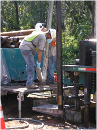
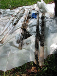
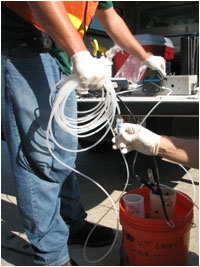
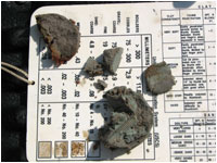
The use of direct-push drilling, field screening and logging tools, and mobile and stationary analytical laboratories allows delineation of both the soil and groundwater plumes in near real time. As samples and data are tested and interpreted in the field, the on-site geologist develops an understanding of the general geology, site stratigraphy, lithology, and mineralogy that characterize the subsurface. These data are then interpreted to determine accurate placement of permanent groundwater monitoring wells needed for delineation of the horizontal and vertical extent of the groundwater plume as well as the hydrologic characteristics of the aquifer(s) beneath the site. Groundwater samples are collected from these wells for laboratory analysis and the analytical results are evaluated to assess the need for additional wells to fully define the spatial extent of the groundwater plume.
Often times, a groundwater monitoring plan will be developed as part of or following the site assessment. Generally the monitoring plan consists of four parts: duration, sampling frequency, selected wells, and analyses. A monitoring period could be one month to several years; however a common duration would be one year. Sampling frequency can vary from weekly to biennially with quarterly sampling being a standard interval. The chosen well network typically consists of an up-gradient well(s), and vertical extent well(s) for each zone of interest such as the upper and lower strata of the surficial aquifer or the surficial aquifer and the Floridian aquifer. Field parameters are routinely measured when ground water samples are collected and can include pH, temperature, conductivity, and water level. Potential laboratory analytes include metals, nutrients, anions and cations, volatile and semi-volatile organic compounds, and pesticides. Field measurements and analytical data are used to monitor the size and magnitude of the contaminant plume and degree and direction of migration, and to evaluate the potential impact to nearby receptors such as potable wells or surface waters.
TERRA-COM geologists manage every aspect of the site assessment and ground water monitoring process to ensure that an accurate understanding of the contaminant type and distribution, area geology, site stratigraphy and hydrogeology, and site history are developed. At this point the assessment process is completed and a detailed engineering evaluation of the assessment results begins.
|
|
|
 |
|
|
|
|
|